PSN Located Events using Earthworm

Last Updated: 03/12/2012

As off Feb. 7th 2012 four events have been located using Earthwork with 5 stations. Currently EW is configured to try and locate an event if 4 stations are triggered in a short period of time. This is the minimum amount of stations  needed to locate events using just the start of the P wave.

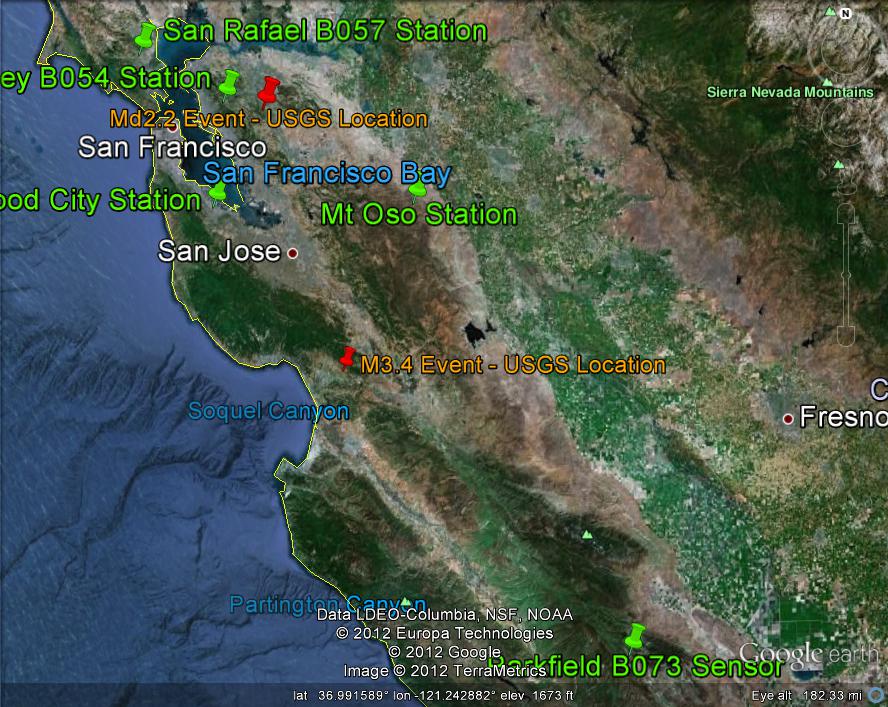
The first event was a M3.4 near Watsonville California at January 26 2012 02:20:19. Below is a GoogleEarth image showing the error between the USGS location reported from their automatic reporting system and our location. Our installation of Earthworm has two modules that try and locate events. One is the EQPROC module and the other is Hypoinverse 2000.


First Event
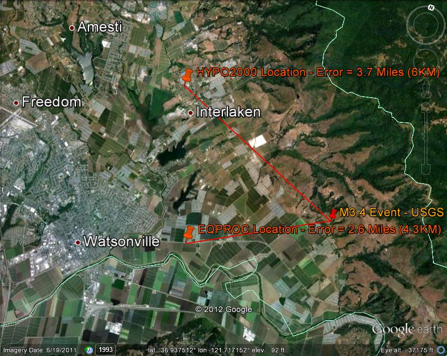
  

Here's the report from the USGS for this event:

CAT    YEAR  MO DA  ORIG TIME   LAT    LONG  DEP  MAGNITUDE
PDE-Q  2012  01 26 022019.50  36.93 -121.68  12  3.4 MLNC      

Here's information form the EQPROC module's log file for this event:

7 2012Jan26  220 19.60  36.9185 -121.7230  8.00 0.08 72.4112.5 190  5
COS   SHZ PN 07 2012Jan26  220 32.48 P D0  72.4   0.00
LCGP2 SHZ PN 01 2012Jan26  220 33.42 P ?3  78.9   0.00
B054  EHZ PB -- 2012Jan26  220 38.25 PnU3 112.8   0.04
B057  EHZ PB -- 2012Jan26  220 41.03 P D2 143.9  -1.15
B073  EHZ PB -- 2012Jan26  220 43.53 P ?2 154.5   0.00

Event Number 2

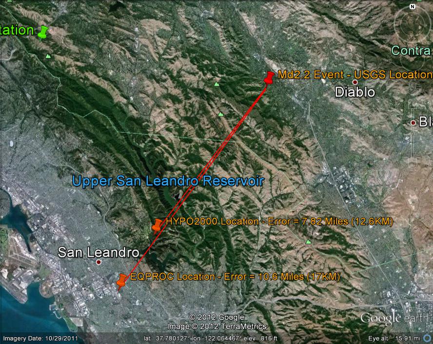
The second event, a small 2.2Md near Danville CA., was not located as well as the first event. Must be beginners luck. One reason for the increase in error is only 4 stations supplied trigger information to locate the event. 
  

USGS Report for this event:

Date       Time             Lat       Lon  Depth   Mag Magt 
-------------------------------------------------------------
2012/01/31 06:56:39.72  37.8317 -122.0265  10.23  2.16   Md  

Hypo2000 Report:

20120131 0656 40.38 37 44.51 122 6.78 8.73 E 2.11 4 198 15. 0.00 6.0 5.7 DW

EQPROC log file:

9 2012Jan31 656 39.73 37.7079 -122.1406 9.43 0.00 17.7 39.6 205 4
COS  SHZ PN 07 2012Jan31 656 52.31 P U3 71.2 0.00
B054 EHZ PB -- 2012Jan31 656 43.57 P U0 17.7 0.00
B057 EHZ PB -- 2012Jan31 656 49.19 P ?0 51.6 0.00
B054 EHZ PB -- 2012Jan31 656 43.57 P U0 17.7 0.00 

This Google Earth image shows the location of the two events in relationship to the stations.


Event Number 3

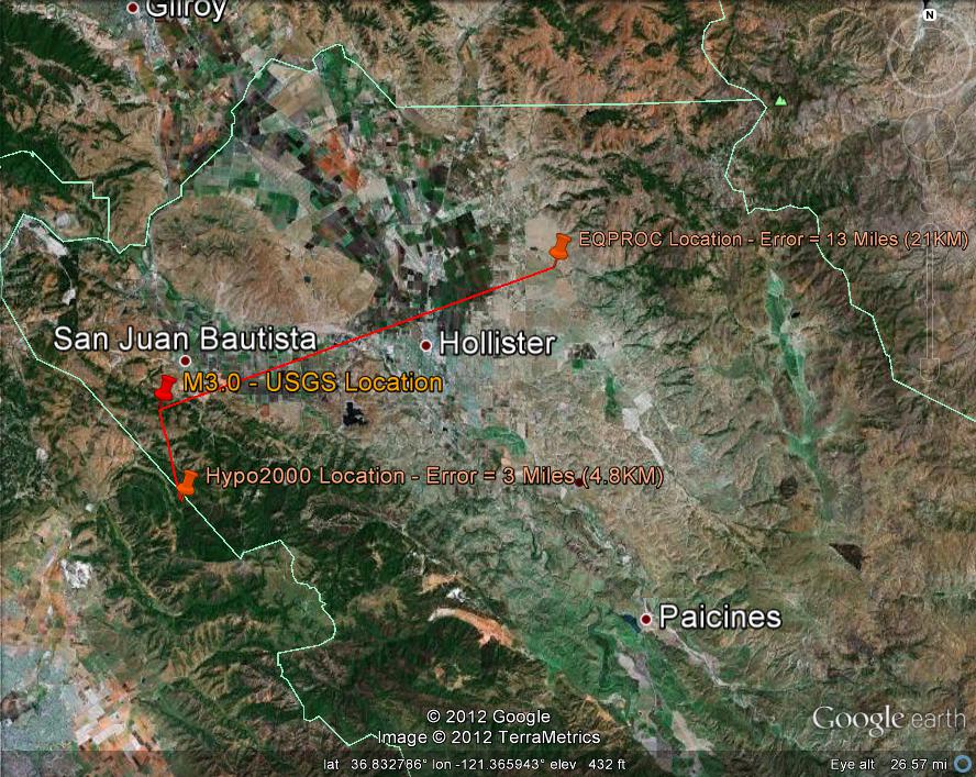
A third event was located by Earthworm on Feb. 9th 2012. Here is the USGS report:

       TIME            LAT     LONG   MAG     DEP          LOCATION
2012/02/09 15:06:08  36.824 -121.552  M3.0    5.1   3 km (  2 mi) SSW of San Juan Bautista, CA

Hypo2000 summary for this event:

YEAR MO DA  --ORIGIN--  --LAT N-  --LON W--  DEPTH   RMS   ERH   ERZ  XMAG1 FMAG1 PMAG
2012-02-09  1506  9.08  36 46.89  121 32.34   9.46  0.00  2.72  2.97        2.82  2.82E

EQPROC Summary:

12 2012Feb 9 1506 10.56  36.8880 -121.3289  8.00 0.02 69.1124.5 175  4
COS   SHZ PN 07 2012Feb 9 1506 22.93 P U3  69.1  -0.00
B057  EHZ PB -- 2012Feb 9 1506 36.10 P D1 167.2  -0.00
B073  EHZ PB -- 2012Feb 9 1506 31.25 P U1 129.1  -0.00
B054  EHZ PB -- 2012Feb 9 1506 31.25 P D3 132.6  -0.45

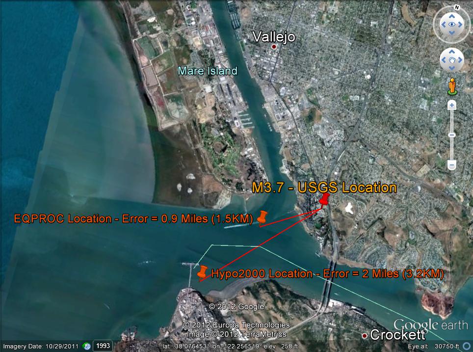
Error Map

Event Number 4

USGS report:

       TIME            LAT     LONG   MAG     DEP          LOCATION
2012/02/16 02:09:14  38.077 -122.231  M3.5    9.3   3 km (  2 mi) NNW of Crockett, CA

Hypo2000 report:

------------------------------------------------------------------------------------
YEAR MO DA  --ORIGIN--  --LAT N-  --LON W--  DEPTH   RMS   ERH   ERZ  XMAG1 FMAG1 PMAG
2012-02-16  0209 15.10  38  3.21  122 15.49   2.49  0.08  2.98 10.36        3.36  3.36E
                                                                                          SOURCE
STA NET COM L CR DIST AZM  AN P/S WT   SEC (TOBS -TCAL -DLY  =RES)  WT   SR  INFO  CAL  DUR-W-FMAG-T -AMP-U-PER-W-XMAG-T DE
B054 PB EHZ -- A 22.1 166  91  PD    19.13  4.03  4.06 0.00 -0.03  1.60  W  0.999 0.00 85.0   3.41 E                        
B057 PB EHZ -- A 27.1 264  91  PU    19.98  4.88  4.88 0.00  0.00  1.60  W  0.999 0.00 77.0   3.34 E                        
LCGP2PN SHZ 01 A 61.8 178  90  P  3  26.03 10.93 10.51 0.00  0.42  0.40  W  0.999 0.00 56.0   3.14 E                        
COS  PN SHZ 07 A 98.6 127  90  PD 3  31.68 16.58 16.50 0.00  0.08  0.40  W  0.999 0.00  150 2 4.13 E                        

EQPROC Summary:

16 2012Feb16 209 14.33 38.0678 -122.2472 2.50 0.01 23.5 53.6 228 4
LCGP2 SHZ PN 01 2012Feb16 209 26.03 P ?3 63.4 0.12
COS SHZ PN 07 2012Feb16 209 31.68 P D3 99.0 -0.00
B057 EHZ PB -- 2012Feb16 209 19.98 P U0 28.5 -0.00
B054 EHZ PB -- 2012Feb16 209 19.13 P D0 23.4 -0.00

Error Map

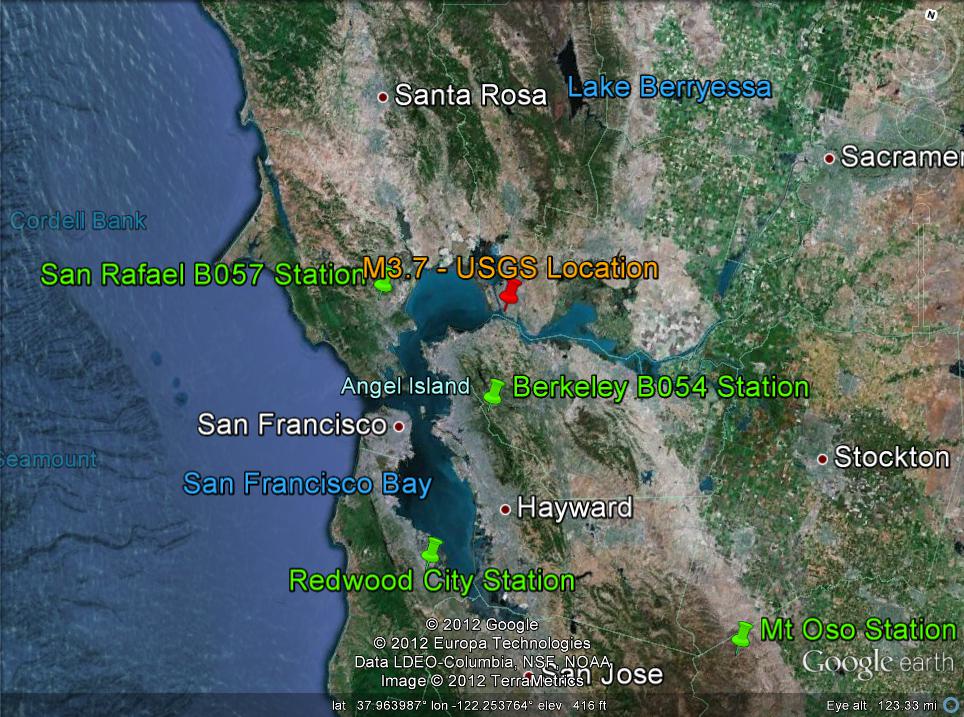
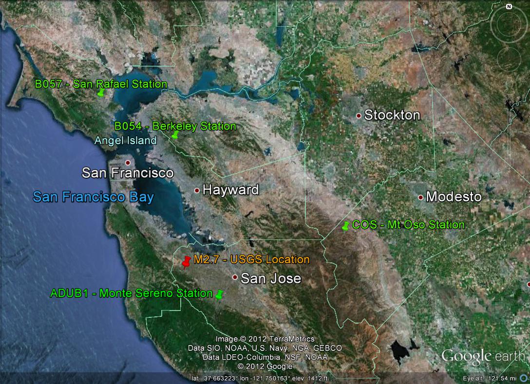
Station Location  


Event Number 5

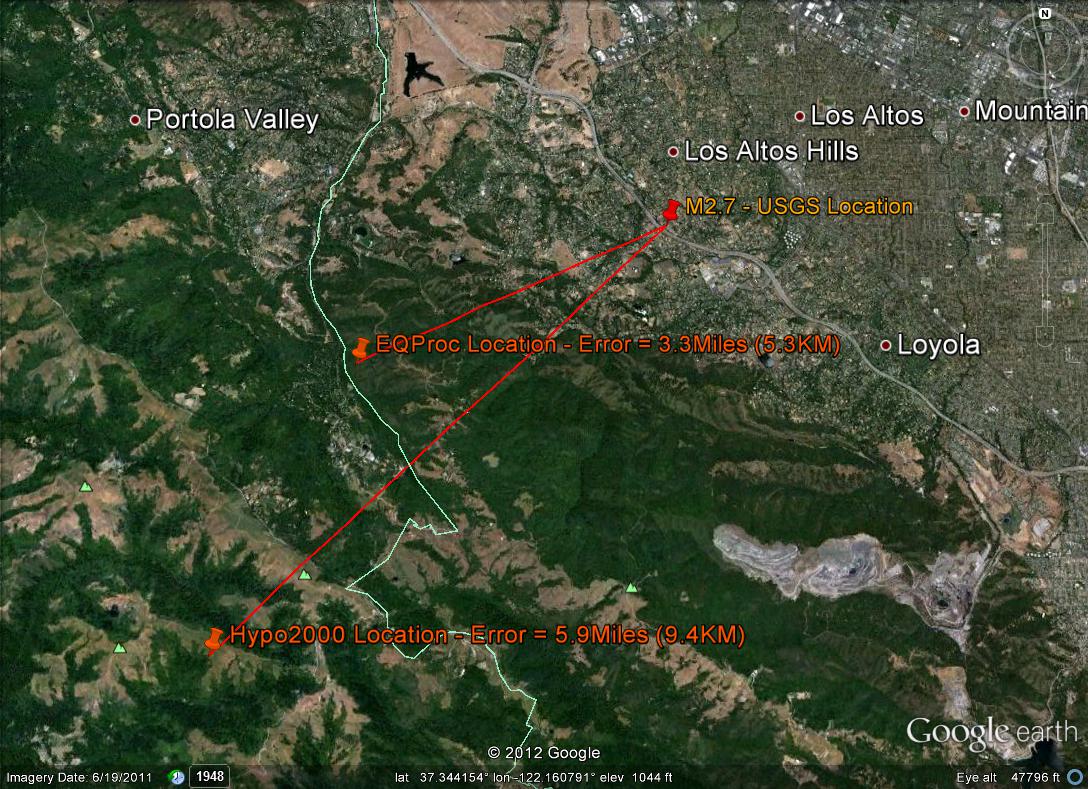
USGS report:

       TIME            LAT     LONG   MAG     DEP          LOCATION
2012/03/10 17:22:59  37.369 -122.139  M2.7    5.8   0 km (  0 mi) SSW of Los Altos Hills, CA

Hypo2000 report:

------------------------------------------------------------------------------------
YEAR MO DA  --ORIGIN--  --LAT N-  --LON W--  DEPTH   RMS   ERH   ERZ  XMAG1 FMAG1 PMAG
2012-03-10  1722 59.37  37 18.57  122 12.95  17.97  0.00  2.46  1.25        2.66  2.66E
                                                                                          SOURCE
STA NET COM L CR DIST AZM  AN P/S WT   SEC (TOBS -TCAL -DLY  =RES)  WT   SR  INFO  CAL  DUR-W-FMAG-T -AMP-U-PER-W-XMAG-T DE
ADUB1PN SHZ 01 A 22.0 108 127  PD 3  64.31  4.94  4.93 0.00  0.01  0.50  W  0.999 0.00 21.0   2.17 E                        
B054 PB EHZ -- A 61.1   1 105  PU    70.12 10.75 10.75 0.00  0.00  2.00  W  0.999 0.00 31.0   2.68 E                        
COS  PN SHZ 07 A 77.7  73 101  PD 3  72.75 13.38 13.37 0.00  0.01  0.50  W  0.999 0.00 51.0   3.18 E                        
B057 PB EHZ -- A 85.4 339  66  P  2  73.90 14.53 14.53 0.00  0.00  1.00  W  0.999 0.00 29.0   2.64 E    

EQPROC Summary:

18 2012Mar10 1722 59.76  37.3482 -122.1935 10.09 0.00 21.9 58.9 216  4
ADUB1 SHZ PN 01 2012Mar10 1723  4.31 P D3  21.9   0.01
COS   SHZ PN 07 2012Mar10 1723 12.75 P D3  74.4   0.01
B054  EHZ PB -- 2012Mar10 1723 10.12 P U0  56.9   0.01
B057  EHZ PB -- 2012Mar10 1723 13.90 P ?2  82.3   0.01

Error Map

Station Location  


Please read the following if you would like to supply data to the PSN Earthworm Network

[ Back ] [ Station Information ] [ Setup Information ]